
Yulla Kanda Trek 2026 - A Guide to the World’s Highest Krishna Temple

The Yulla Kanda trek, in the Kinnaur district of Himachal Pradesh, is an exceptional confluence of alpine wilderness and mountain devotion. The trail culminates at a sacred glacial lake and what is widely recognised as the world’s highest Lord Krishna temple, at approximately 3,895 metres (12,779 feet). Unlike commercialised Himachal trails like Triund or Hampta Pass, Yulla Kanda preserves an untouched ecological character with low tourist footfall and pristine surroundings.
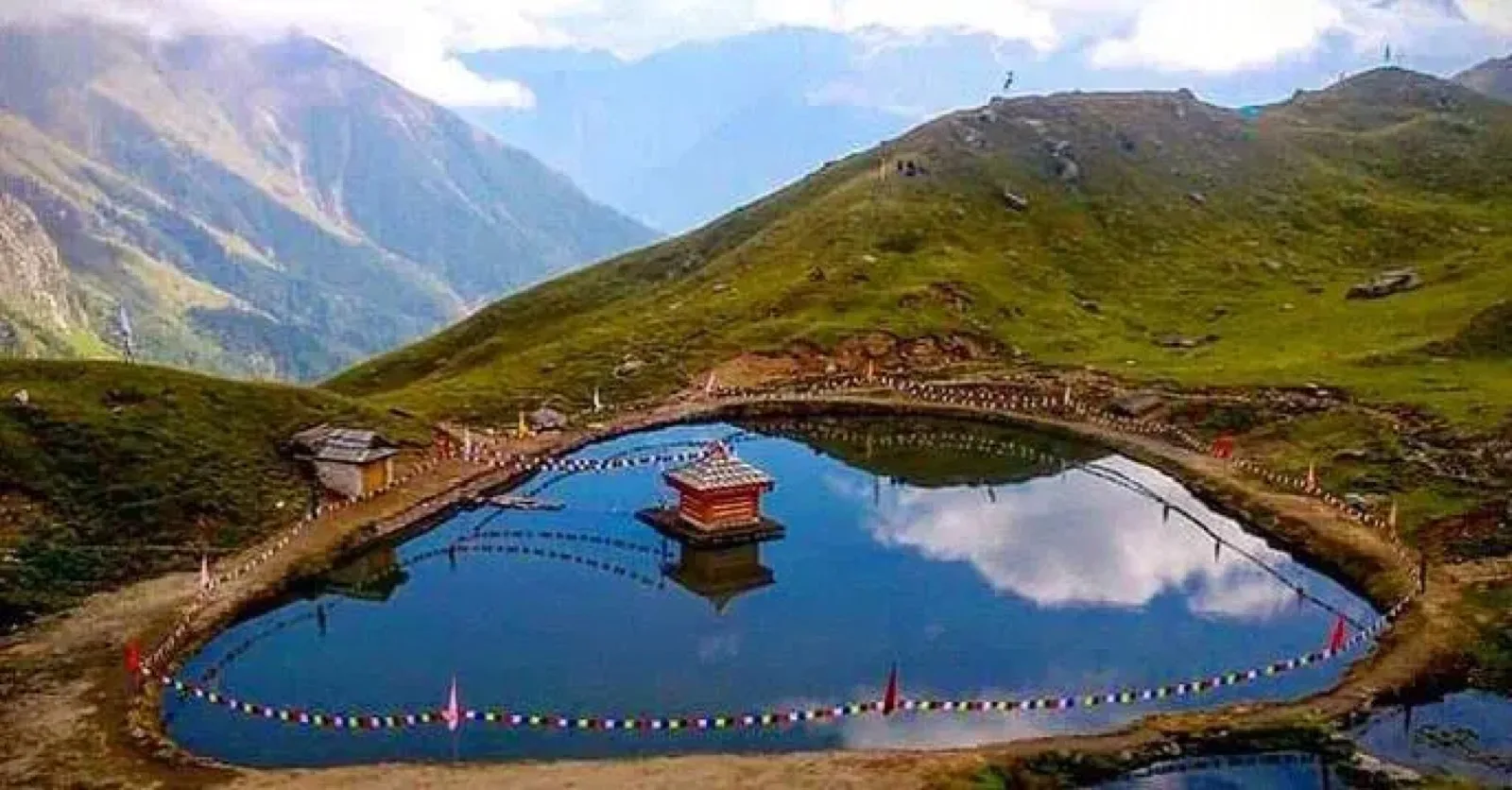
Quick facts about Yulla Kanda
- Location: Rora Valley, near Yulla Khas village, Nichar tehsil, Kinnaur district, Himachal Pradesh
- Altitude (lake and temple): ~3,895 m (12,779 ft)
- Trailhead base elevation: ~2,985 m (Yulla Khas village)
- Main attraction: World’s highest Lord Krishna temple beside a high-altitude glacial lake
- Trek starting point: Yulla Khas village (road-head near Tapri)
- Total trek distance: 20-24 km round trip
- Difficulty: Moderate to difficult high-altitude trek
- Best time: Mid-May to October, peak in June, September, early October
- Major festival: Krishna Janmashtami in August with large local pilgrimage
- Accommodation: Village homestays plus trekking camps; no hotels at the lake
Why Yulla Kanda is special
Unlike the vast majority of high-altitude Himalayan shrines located above 3,500 metres - which are almost exclusively dedicated to Lord Shiva or localised nature devtas - the Yulla Kanda temple is dedicated to Lord Krishna. Krishna, an incarnation of Lord Vishnu, is traditionally associated with the pastoral plains, agricultural basins, and river valleys of lowland India. The presence of a Vaishnavite shrine this high represents a fascinating cultural adaptation by historical transhumant pastoralists who carried their devotion into the mountain heights.
Key reasons travellers and pilgrims make the climb:
- It is widely described as the world’s highest Lord Krishna temple, set beside a high-altitude lake.
- The lake is crystal clear and mirrors surrounding snow peaks and alpine meadows.
- The area is still non-commercial: no shops or hotels near the lake, so the site remains clean and quiet.
- The trek passes through forests, meadows, and rugged mountain slopes - the journey itself is half the experience.
- From the summit you get a 360-degree view of the surrounding ranges, including the prominent granite monolith of Kinner Kailash (6,050 m).
The legend of the Pandavas
According to regional oral history and Hindu mythology, the temple and surrounding lake were created by the Pandava brothers of the Mahabharata during their twelve-year exile in the Himalayas. The glacial lake is traditionally referred to in local dialects as "Dhan ki Kheti", which translates to "field of rice". This title is spiritually linked to beliefs regarding regional abundance, agricultural fertility, and divine protection. A ritual dip in the freezing waters of the lake is believed to cleanse the mind and body of negative energies.
The main idol of Krishna in the temple is regarded as swayambhu (self-manifested) - meaning it emerged naturally from the rock and was not carved by humans - which makes it especially sacred in local belief.
Architectural character of the temple

Reflecting the traditional, rustic craftsmanship of the Kinnaur region, the temple features a humble, minimalist design. Constructed from local stone and deodar wood, it sits on a small, rocky, island-like outcrop near the centre of the glacial lake. The wooden elements carry elegant local carvings. The temple lacks the soaring gopurams or elaborate stone carvings of lowland temples - that simplicity lets the structure blend with its mountain backdrop and emphasises silent contemplation. The temple is open daily from 9:00 AM to 5:00 PM.
During Janmashtami, which celebrates the birth of Lord Krishna, the site experiences a massive influx of devotees. Pilgrims from across Himachal Pradesh travel to the lake, with many completing the final steep ascent barefoot while chanting mantras and singing traditional folk songs.
The floating Kinnauri cap ritual
A defining custom of the Yulla Kanda pilgrimage is the "floating cap" ritual, which uses the traditional woolen Kinnauri Topi. Devotees and visiting travellers place the cap upside-down on the surface of the glacial lake.
If the cap floats across to the opposite shore without tilting or sinking, it serves as a divine omen of peace, prosperity, and the fulfilment of the individual’s wishes in the coming year. If the cap sinks, it is viewed as a cautionary sign, prompting self-reflection.
Best time to visit Yulla Kanda

Because of heavy snow, Yulla Kanda is accessible only for a few months each year.
- Season window: Late April or mid-May to October, depending on snow conditions.
- Peak trekking months: June, September, and early October - relatively stable weather and clearer skies.
- Janmashtami (August): The biggest festival at Yulla Kanda. Large numbers of devotees trek up for Krishna celebrations.
In winter, the area is usually covered in snow, and the route is risky or closed.
Standard 4-day itinerary
Day 0 to Day 1: Transit and acclimatisation

The journey begins with an overnight drive from Delhi to Shimla (typically 9-10 PM departure from Kashmiri Gate ISBT or Mukarba Chowk, 10-12 hours via Chandigarh). From Shimla, the route follows National Highway 5 (the Hindustan-Tibet Road) for 200 km along the dramatic gorges of the Sutlej River.
The drive passes Rampur Bushahr - a historic trading town that once served as a primary commercial hub between India and Tibet - with steep terraced hillsides heavy with apple and apricot orchards. At Tapri, a local jeep takes travellers 20 km up a steep mountain road to Yulla Khas village. Yulla Khas sits at 2,985 m - spending the first afternoon and night in a homestay is vital to prevent high-altitude sickness.
Day 2: Forest climb to Yulla base camp
10-12 km trek from Yulla Khas to the Yulla base camp, typically 4-6 hours. The trail begins as stone stairs winding through village houses before entering a dense temperate forest of pine, oak, and deodar, with pristine glacial waterfalls visible on the right.
As the trail ascends, the forest canopy thins, transitioning into subalpine rhododendrons, juniper, and alpine shrubs. At approximately 3,500 m, the forest ends, marked by a physical steel gate - the boundary between the resource-use zones of the lower forest and the sacred high-altitude alpine meadows (bugyals). The base camp is established in these open meadows; trekkers spend the night in alpine tents.
Day 3: Summit push and descent
The third day begins with a pre-dawn climb to Yulla Kanda Lake. The distance is only 2 km, but the steep gradient and thin air at 3,895 m make it physically demanding. Reaching the summit reveals the sacred lake, the Krishna temple, and a panoramic 360-degree view including the granite monolith of Kinner Kailash (6,050 m). After prayers and exploring the lake, trekkers descend back to base camp for breakfast, continue down to Yulla Khas village, and prepare for the return drive the following day.
Stay and food options
There are no hotels, restaurants, or permanent shops at the lake or temple area. Most trekkers stay in:
- Village homestays: Simple, home-style stays in Tapri or Yulla Khas, often with local Kinnauri food.
- Tented camps: Temporary camping at the base camp meadow, usually arranged by trek operators.
Food is basic but tasty - dal, rice, vegetables, roti, tea, and sometimes local Kinnauri dishes.
Packing list for the Yulla Kanda trek
Essentials for a high-altitude trek of this nature:
- Good trekking shoes with strong grip and ankle support
- 40-60 litre rucksack with rain cover plus a small daypack
- Warm layers: thermals, fleece, down or padded jacket (sub-zero rated), woolen cap and gloves
- Windproof and waterproof outer layer or poncho
- Trek pants and quick-dry T-shirts; avoid heavy jeans
- Sunglasses, sun cap, and high SPF sunscreen and lip balm
- Personal medicines, basic first-aid, and any altitude-related medication advised by a doctor
- Torch or headlamp, power bank, water bottle, and high-energy snacks
Safety, altitude, and physical preparation
Physical conditioning
To prepare for the steep climbs and thin air, travellers should undertake a structured 6-week cardiovascular training program. Focus on leg strength, aerobic endurance, and lung capacity, supplemented by day hikes carrying a loaded 7-10 kg backpack to simulate trail conditions.
Altitude sickness and hydration
Because Yulla Khas sits higher than many common hill stations, Acute Mountain Sickness (AMS) is a real risk. Travellers must consume 3-4 litres of water daily for hydration and acclimatisation. If persistent symptoms - severe headache, nausea, extreme fatigue, breathlessness - develop, stop climbing and descend immediately.
Navigation and wildlife
The upper meadows lack clear trail markings, and sudden mountain fog can severely reduce visibility. Stay on the established single-track trail and avoid shortcuts. In October 2022, a pair of hikers attempting a shortcut to the summit shelter became trapped in total darkness among dense thorny bushes - a documented hazard.
Hikers should remain alert to local wildlife including the Himalayan monal, barking deer, and occasional snow leopards or ibex. During autumn, transhumant shepherds move large flocks down the slopes, sometimes occupying shelter huts. Exercise caution with abandoned camp gear - high-altitude snakes are known to seek warmth under it.
Inner Line Permit regulations
Indian citizens
Indian citizens do not require any Inner Line Permit (ILP) or special administrative permission to travel through Kinnaur or complete the Yulla Kanda trek. They can travel freely along NH-5 up to the Spiti Valley, needing only a valid government photo ID (such as Aadhaar) for checkpoint registration.
Foreign nationals
Foreign nationals can visit Lower Kinnaur (Yulla Khas, Kalpa, Sangla Valley, Chitkul, Sarahan) without an Inner Line Permit. A permit is only required if travelling beyond the Jangi checkpost into Upper Kinnaur (Pooh block) or toward Spiti.
Foreign tourists must travel in groups of two or more, accompanied by a guide from a registered Indian travel agency, with a pre-defined itinerary. Photography is strictly prohibited near military installations, and access roads to Shipkila and Kaurik are closed to foreign passport holders. The physical presence of the foreign applicant is mandatory at the administrative office when the permit is signed.
Permit processing fees: SDM Office Kalpa (Reckong Peo) ₹250 - most efficient with digital photos on-site; Sugam Center Shimla ₹400 - convenient for those starting from Shimla; SDM Kaza / Keylong ₹200-400 - for travellers entering from the Manali side. The ILP is valid for 15 days from issue; carry 5-6 photocopies for various police checkpoints (notably Jangi and Sumdo).
Responsible travel tips
Because Yulla Kanda is both a natural and sacred site, responsible behaviour is essential:
- Do not litter; carry back all plastic and waste from the lake and camping areas.
- Do not pollute the lake by bathing or washing utensils directly in the water.
- Respect local customs: remove shoes near the temple, dress modestly, follow temple caretakers’ instructions.
- Avoid loud music or shouting near the lake - locals treat the area as a natural temple.
- Hire local guides, porters, and homestays to support the village economy.
Surrounding attractions you can combine with the trek
- Reckong Peo and Kalpa (~35 km from Tapri) - Kinnaur administrative headquarters; views of sacred Kinner Kailash peak and traditional wooden temples.
- Sangla Valley and Chitkul (~60 km) - The last inhabited village near the Indo-Tibetan border; traditional wood-and-stone architecture along the Baspa River.
- Khab Sangam (~110 km) - Confluence of the Sutlej and Spiti rivers; dramatic geographic transition near the Tibetan border.
- Kamru Fort (~55 km) - Historic tower-style fort in Sangla, dedicated to the deity Kamakhya Devi.
- Nako Sacred Lake (~125 km) - High-altitude lake surrounded by a Buddhist monastery and willow trees in the Spiti transition zone.
Frequently asked questions about Yulla Kanda
Where is Yulla Kanda located?
Yulla Kanda is located above Yulla Khas village in the Rora Valley, Nichar tehsil, Kinnaur district of Himachal Pradesh. The trail falls within the lower range of the Rupi-Bhaba Wildlife Sanctuary. The base village sits near Tapri, a transit town along National Highway 5 (the Hindustan-Tibet Road).
Why is Yulla Kanda famous?
Yulla Kanda is widely recognised as the location of the world’s highest Lord Krishna temple, set beside a sacred glacial lake at approximately 3,895 metres (12,779 feet). Unlike most high-altitude Himalayan shrines which are dedicated to Lord Shiva, Yulla Kanda is unusual for being a Vaishnavite (Krishna) shrine at this altitude. Regional legend connects the lake and temple to the Pandavas during their Mahabharata-era exile.
What is the altitude of Yulla Kanda?
The Yulla Kanda lake and temple sit at approximately 3,895 metres (12,779 feet) above sea level. The trailhead at Yulla Khas village is at about 2,985 metres (9,793 feet), so the trek involves roughly 910 metres of vertical gain over 10-12 km on the ascent side.
How difficult is the Yulla Kanda trek?
The Yulla Kanda trek is rated moderate to difficult. The route is 20-24 km round trip with a steep, thin-air final summit push of about 2 km from the base camp meadow. Good basic fitness is essential. Travellers should undertake a structured 6-week cardiovascular training program before the expedition, focusing on leg strength, aerobic endurance, and lung capacity.
When is the best time to visit Yulla Kanda?
The trek is accessible from mid-May to October, with June, September, and early October offering the most stable weather and clearer skies. Janmashtami in August is the biggest festival at Yulla Kanda, when large numbers of devotees trek up for Krishna celebrations. In winter the area is covered in snow and the route is risky or closed.
Do I need an Inner Line Permit for Yulla Kanda?
Indian citizens do not need any Inner Line Permit to visit Yulla Khas or trek Yulla Kanda - a valid government photo ID (such as Aadhaar) is sufficient at checkposts. Foreign nationals do not need a permit for Yulla Khas, Kalpa, Sangla, Chitkul, or Sarahan, but a permit is required if travelling beyond the Jangi checkpost into Upper Kinnaur or Spiti. Foreign tourists must travel in groups of two or more with a guide from a registered Indian travel agency.
Are there hotels at Yulla Kanda lake?
No - there are no hotels, restaurants, or permanent shops at the lake or temple area. Trekkers stay in village homestays in Tapri or Yulla Khas before and after the trek, and use tented camps at the base meadow during the trek itself. The site is deliberately non-commercial, which is part of why it has retained its untouched character.
What is the floating Kinnauri cap ritual at Yulla Kanda?
Devotees and visitors place a traditional woolen Kinnauri Topi upside-down on the surface of the glacial lake. Local belief holds that if the cap floats across to the opposite shore without tilting or sinking, it is a divine omen of peace, prosperity, and the fulfilment of the individual’s wishes in the coming year. If the cap sinks, it is viewed as a cautionary sign prompting self-reflection.